


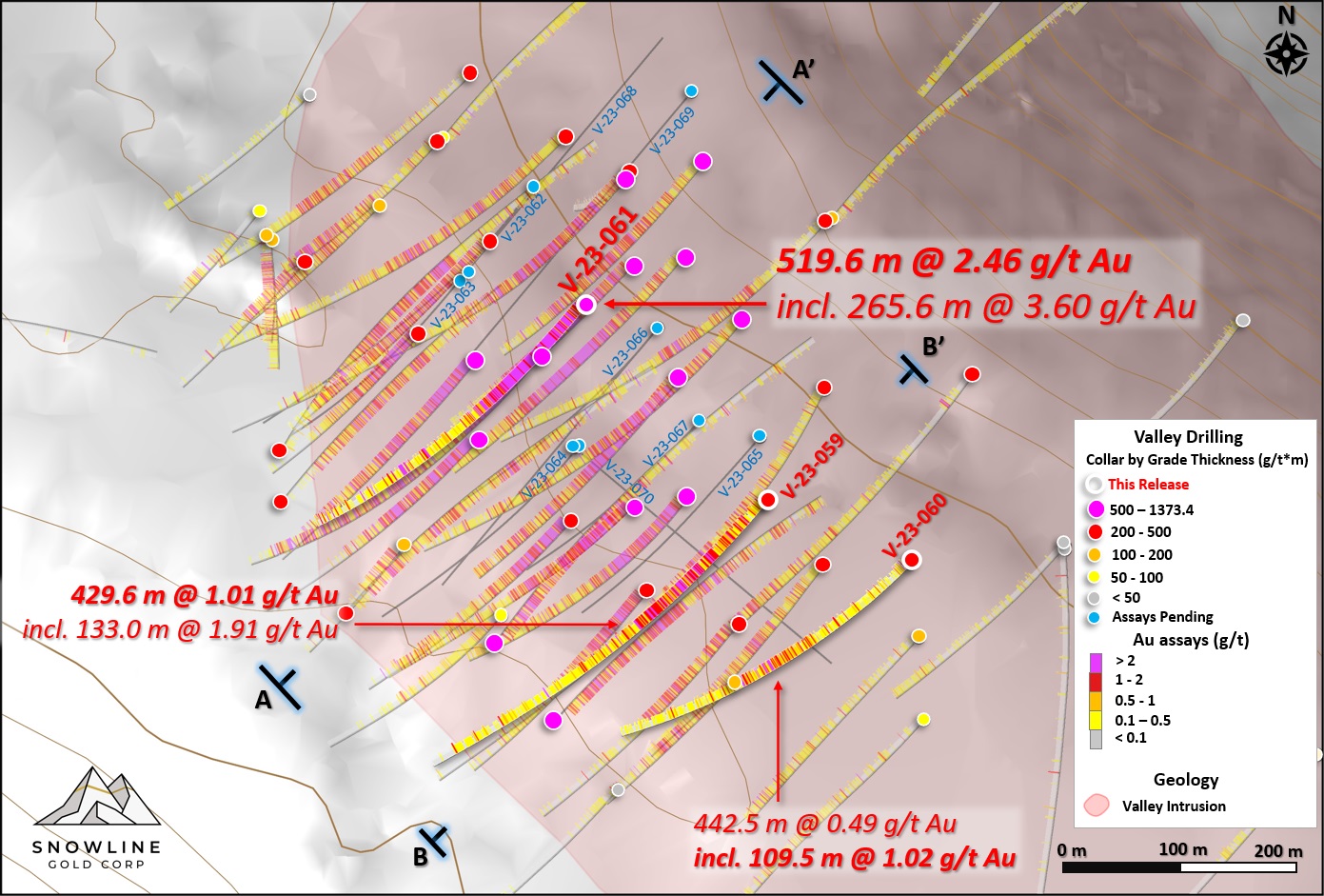
- Hole V-23-061 returned 519.6 m averaging 2.46 g/t Au, including 3.60 g/t Au over 265.6 m from surface, the strongest near-surface mineralization (upper 250 vertical metres) encountered to date on the Rogue Project's Valley target
- Hole V-23-059 and V-23-060 demonstrate strong continuity and breadth in the southeastern part of the Valley system, returning 429.6 m averaging 1.01 g/t Au from surface (including 1.91 g/t Au over 133.0 m) and 109.5 m averaging 1.02 g/t Au respectively.
- Analytical results pending for 5,475 m from 16 holes (including one metallurgical hole at Valley) across 3 targets in addition to results of extensive surface exploration campaign.
VANCOUVER, BC / ACCESSWIRE / December 6, 2023 / SNOWLINE GOLD CORP (TSX-V: SGD) (OTC: SNWGF) (the "Company" or "Snowline") is pleased to announce analytical results from additional exploration holes drilled on its Rogue Project in Canada's Yukon Territory. Hole V-23-061 returned 2.46 g/t Au over 519.6 m from surface, including 3.60 g/t Au over 265.6 m downhole, demonstrating a strong consistency of near-surface, multiple-gram-per-tonne-gold mineralization. Holes V-23-059 and V-23-060 were drilled within the southeast extension of the system and add dimensionality and consistency to known mineralization in that direction. Assays for more than 5,475 m of diamond drilling from Snowline's 2023 exploration efforts remain pending.

"The Valley discovery on our 100%-owned, district-scale Rogue Project continues to demonstrate strong, continuous gold mineralization across a large area from surface," said Scott Berdahl, CEO & Director of Snowline. "Hole V-23-061 returned the strongest gold interval we've seen near surface in any hole to date, highlighting the favorable characteristics of the Valley system for efficient mining-namely strong, consistent mineralization with the highest grades beginning at or near surface in a topographically advantageous position. With December upon us, we have much to look forward to in terms of additional drill results, surface exploration results, advanced metallurgical testing and of course an aggressive exploration season ahead in 2024 on Valley and other targets across our >330,000 ha land position."
HOLE V-23-061
Hole V-23-061 is collared in coarse-grained granodiorite within the Valley intrusion roughly 60 m northeast of V-22-039 (553.8 m @ 2.48 g/t Au including 183.3 m @ 4.34 g/t Au from surface, see Snowline news release dated August 3, 2023) and 51 m southwest of V-23-037 (383.8 m @ 2.47 g/t Au from surface including 120.0 m @ 4.06 g/t Au, same news release). It continues in coarse-grained granodiorite for the length of the hole, intersecting two small (1 m scale) dikes of fine-grained granodiorite (Figure 2).
The hole commences in strong, sheeted gold-bearing quartz vein mineralization (Figure 3) from bedrock surface at 5.5 m downhole and continues in strong mineralization until approximately 270 m downhole, where the hole intersects a central, valley-parallel fault. Quartz vein densities drop off below the fault, but lower grade mineralization continues for the remainder of the hole. Vein orientations in the lower part of the hole generally run at low angles to the drill core, whereas in the upper part of the hole they are consistent with the dominant, steeply dipping northwest striking vein array seen across the Valley intrusion.

Overall, the top 519.6 m downhole from bedrock surface average 2.46 g/t Au, with an internal interval of 265.6 m averaging 3.60 g/t Au also beginning from surface. This sub interval is the strongest near-surface (upper 250 vertical metres from bedrock surface) mineralized intersection from the Valley target to date. Within this, a zone of sustained higher grades beginning at 149.0 m downhole averages 6.47 g/t Au over 47.5 m.
As seen in Figure 2, the consistency of strong, near-surface mineralization in V-23-061 is emphasized by the even distribution of grades. Within the top 265.6 m interval downhole from bedrock surface, 90% of assays (measured by core length) returned >1 g/t Au and no assays returned <0.4 g/t Au. As with many other holes at Valley, capping mineralization at 10 g/t Au has only a minor effect on grades-in the near surface interval, the capped average is 3.4% lower, at 3.48 g/t Au instead of 3.60 g/t Au over the 265.6 m downhole interval. Within this, the 143.0 m downhole stretch from 68.5 m to 211.5 m represents the longest interval to date at Valley without a single assay value <1.0 g/t Au. Nearly half (46.1%) of the assays within this interval are above 4.0 g/t Au, and 82.8% returned greater than 2.0 g/t Au. (The average grade over this 143.0 m interval is 4.54 g/t Au.)
Towards the bottom of the broader 519.6 m interval, beginning at 514.0 m downhole, a quartz vein roughly 2 cm wide running subparallel to the core for approximately 1 metre was intersected, with abundant millimetre to sub-millimetre scale instances of visible gold. This interval yielded 154.7 g/t Au across 1.0 m downhole (with a localized true width closer to the 5.1 cm diameter of the drill core).
The hole ends with a second interval of mineralization beginning at 534.0 m downhole and averaging 0.35 g/t Au over 64.0 m. Gold values within this interval have higher variance, owing to the lower vein density and the subparallel orientation of the veins to the drilling direction.


HOLE V-23-059
Hole V-23-059 is collared in coarse-grained granodiorite of the Valley stock, on section between V-23-044 (295.9 m @ 1.32 g/t Au from surface including 157.0 m @ 2.03 g/t Au, see Snowline news release dated September 11, 2023) roughly 132 m to its southwest and V-22-027 (481.5 m @ 0.69 g/t Au including 250.0 m @ 1.01 g/t Au, see Snowline news release dated January 18, 2023) roughly 108 m to its northwest (Figures 1 and 4).
The hole encountered sheeted gold-bearing quartz vein mineralization from bedrock surface at 6.9 m downhole. The full interval of continuous mineralization within the hole averages 1.01 g/t Au over 429.6 m from bedrock surface, with a higher-grade zone averaging 1.97 g/t Au over 105.5 m from 112.0 m downhole. A second interval of lower grade mineralization (0.28 g/t Au over 44.0 m from 450.0 m downhole) is present near the edge of the intrusion. The hole exits the intrusion at 507.0 m downhole into primarily non-mineralized hornfels.
Gold grades in V-23-059 are not affected by grade capping at 10 g/t Au, demonstrating the consistent nature of mineralization across the broad mineralized interval.
Both V-23-059 and V-23-060 add breadth to the known extent of near-surface >1 g/t Au (to nearly 2.0 g/t Au in the case of V-23-059) mineralization in the southeast extension of the Valley gold system.

REGIONAL DRILLING
Gracie Target, Rogue Project
At Gracie, assays for G-23-008 and G-23-009 have been received (Table 3). These holes were drilled in the western and southern parts of the zone of hornfels at Gracie, away from the primary planned hole locations which were postponed due to technical conditions at the pad sites. Both holes intersected long runs of hornfels sandstones, siltstones and cherts, with rare quartz veins and varying degrees of silicification along with biotite and chlorite alteration. Gold values were generally low, with elevated to anomalous gold values of up to 1.57 g/t over 0.8 m.
The results will be used alongside previous drilling, geophysics, surface geochemistry and mapping to determine an optimal follow-up drilling strategy for the Gracie target.

QA/QC
On receipt from the drill site NQ2-sized drill core was systematically logged for geological attributes, photographed and sampled at Snowline's 2023 field camp. Sample lengths as small as 0.5 m were used to isolate features of interest, but most samples within moderate to strong mineralization were 1.0 m in length; otherwise, a default 1.5 m downhole sample length was used. Core was cut in half lengthwise along a pre-determined line, with one half (same half, consistently, dictated by orientation line where present or by dominant vein orientation where absent) collected for analysis and one half stored as a record. Field duplicates were collected at regular intervals as ¼ core samples by splitting the ½ core sent for sampling, leaving a consistent record of half core material from duplicate and non-duplicate samples alike. Standard reference materials and blanks were inserted by Snowline personnel at regular intervals into the sample stream. Bagged samples were sealed with security tags to ensure integrity during transport. They were delivered by expeditor to Bureau Veritas' preparatory facility in Whitehorse, Yukon. Sample preparation was completed in Whitehorse, with analyses completed in Vancouver.
Similar procedures were employed on the Tosh Project, though drill core was transported to Whitehorse in advance of detailed logging and sampling.
Bureau Veritas is accredited to ISO/IEC 17025 and ISO9001 for quality management. Samples were crushed by BV to >85% passing below 2 mm and split using a riffle splitter. 250 g splits were pulverized to >85% passing below 75 microns. A four-acid digest with an inductively coupled plasma mass spectroscopy (ICP-MS) finish was used for 59-element analysis on 0.25 g sample pulps (BV code: MA250). All samples were analysed for gold content by fire assay with an atomic absorption spectroscopy (AAS) finish on 30 g samples (BV code: FA430). Any sample returning >10 g/t Au was reanalysed by fire assay with a gravimetric finish on a 30 g sample (BV code: FA530).
For the purposes of this release, mineralized intervals are defined as runs of mineralization with no break >5.0 m assaying <0.1 g/t Au, including any subsections thereof.
ABOUT ROGUE
The Valley target on Snowline's flagship Rogue Project is a newly discovered, bulk tonnage style, reduced intrusion-related gold system (RIRGS), with geological similarities to multi-million-ounce deposits currently in production such as Kinross's Fort Knox Mine in Alaska and Victoria Gold's Eagle Mine in the Yukon. Early drill results demonstrate unusually high gold grades for such a system, present near surface across drill intersections of hundreds of metres. Gold is associated with bismuthinite and telluride minerals hosted in sheeted quartz vein arrays within and along the margins of a one-kilometer-scale, mid-Cretaceous aged Mayo-suite intrusion. Valley is an early-stage exploration project without a resource estimate, and while initial results are encouraging, the presence or absence of an economically viable orebody cannot be determined until additional work is completed.
The Rogue Project area hosts multiple intrusions similar to Valley along with widespread gold anomalism in stream sediment, soil and rock samples. Elsewhere, RIRGS deposits are known to occur in clusters. The Rogue Project is thus considered by the Company to have district-scale potential for additional reduced intrusion-related gold systems.
ABOUT SNOWLINE GOLD CORP.
Snowline Gold Corp. is a Yukon Territory focused gold exploration company with an eight-project portfolio covering >333,000 ha. The Company is exploring its flagship >94,000 ha Rogue gold project in the highly prospective yet underexplored Selwyn Basin. Snowline's project portfolio sits within the prolific Tintina Gold Province, host to multiple million-ounce-plus gold mines and deposits including Kinross's Fort Knox Mine, Newmont's Coffee deposit, and Victoria Gold's Eagle Mine. The Company's first-mover land position and extensive database provide a unique opportunity for investors to be part of multiple discoveries and the creation of a new gold district.

QUALIFIED PERSON
Information in this release has been prepared under supervision of and approved by Thomas K. Branson, M.Sc., P. Geo., VP Exploration of Snowline Gold Corp, as Qualified Person for the purposes of National Instrument 43-101.
ON BEHALF OF THE BOARD
Scott Berdahl
CEO & Director
For further information, please contact:
Snowline Gold Corp.
+1 778 650 5485
info@snowlinegold.com
Neither TSX Venture Exchange nor its Regulation Services Provider (as that term is defined in policies of the TSX Venture Exchange) accepts responsibility for the adequacy or accuracy of this release.
CAUTIONARY NOTE REGARDING FORWARD-LOOKING STATEMENTS
This news release contains certain forward-looking statements, including statements regarding the significance of analytical results, cost-effective production of gold, the discovery potential within the Valley intrusion, the potential for investors to participate in multiple future discoveries, the Rogue project having district-scale prospectivity, the creation of a new gold district and the Company's future plans and intentions. Wherever possible, words such as "may", "will", "should", "could", "expect", "plan", "intend", "anticipate", "believe", "estimate", "predict" or "potential" or the negative or other variations of these words, or similar words or phrases, have been used to identify these forward-looking statements. These statements reflect management's current beliefs and are based on information currently available to management as at the date hereof.
Forward-looking statements involve significant risk, uncertainties and assumptions. Many factors could cause actual results, performance or achievements to differ materially from the results discussed or implied in the forward-looking statements. Such factors include, among other things: risks related to uncertainties inherent in drill results and the estimation of mineral resources; and risks associated with executing the Company's plans and intentions. These factors should be considered carefully, and readers should not place undue reliance on the forward-looking statements. Although the forward-looking statements contained in this news release are based upon what management believes to be reasonable assumptions, the Company cannot assure readers that actual results will be consistent with these forward-looking statements. These forward-looking statements are made as of the date of this news release, and the Company assumes no obligation to update or revise them to reflect new events or circumstances, except as required by law.
SOURCE: Snowline Gold Corp.
View source version on accesswire.com:
https://www.accesswire.com/813772/snowline-gold-intersects-5196-m-of-25-grams-per-tonne-gold-including-2656-m-of-36-grams-per-tonne-gold-from-surface-in-strongest-near-surface-interval-to-date-at-its-valley-target-rogue-project-yukon
